Colorado reservoir proposal fans flames of climate change, trans-mountain diversion debate

Where were you in ’52?
That’s the year the Colorado Front Range cities of Aurora and Colorado Springs first started gobbling up water rights in the remote, somewhat lush mountain valley carved by Homestake Creek on the state’s mountainous Western Slope.
To be clear, every stream, creek, spring and rivulet on the Western Slope, or west of the Continental Divide, flows into the Colorado River in a generally southwesterly direction toward the Gulf of California and the Pacific Ocean – although 40 million thirsty souls along that once-mighty river (coupled with climate change) have now caused it to seep into the sand short of the Sea of Cortez and recently prompted a first-ever federal water shortage declaration.
Every brook, rill and runnel on Colorado’s Eastern Slope, also known as its Front Range, flows toward the Gulf of Mexico and the Atlantic Ocean. The Front Range is where 80% of the state’s residents reside; while approximately 80% of their water comes from the Western Slope via engineering feats (unnatural plumbing exercises) known as transmountain diversions.

Colorado’s number two (Colorado Springs, 478,961) and number three (Aurora, 386,261) cities by population would like to sop up another 20,000 acre-feet of water from the Homestake Creek Valley southwest of tiny Red Cliff (population 280) and send it under the Continental Divide and eventually into pipes and onto lawns in their Front Range neighborhoods.
[One acre foot is enough to cover one acre of land — about the size of a football field — one foot deep in water. Aurora Water says one acre foot can supply about three homes for a year.]
The new reservoir they’d like to build would be around five miles downstream from the existing Homestake Reservoir and would be called Whitney Reservoir after a creek that flows into Homestake Creek and a peak in the nearby Holy Cross Wilderness Area, which they might have to cut into by up to 500 acres.
To be even more clear, the two cities – doing business as Homestake Partners – have owned those 20,000 acre-feet of annual yield since the 1950s, when they also had the foresight to buy up enough water rights to build Homestake Reservoir in 1967 – a 43,600-acre-foot storage basin that the two cities currently get about 21,000 acre feet out of every year.
The two cities quietly – at least in terms of the lack of press releases and ribbon cuttings – began the work of test drilling for four possible dam sites along Homestake Creek in recent weeks, even as protestors were marching on Red Cliff and environmental groups said they would sue just to stop the testing on U.S. Forest Service land.
“We’re disappointed to see drilling under way before the USFS and [U.S. Fish and Wildlife Service] respond to the concerns raised in our July 7 Notice of Intent letter,” Peter Hart, an attorney for Wilderness Workshop, told RealVail.com. “The drilling will negatively impact wildlife, wetlands, and recreation in the Homestake Valley. At this time, we’re considering all our options.”
If one of four alternatives is deemed feasible, then the real fight starts with full environmental review by the Forest Service, which says it won’t even consider a reservoir proposal that shrinks a wilderness area until the cities get that approved by Congress and the White House, both of which currently seem more inclined to grow the nation’s wilderness acreage.
The U.S. congressman for the district, rising Democratic star Joe Neguse (a Front Range resident), has made it clear he’s not really into wilderness shrinkage, nor is he thrilled about possibly inundating wetlands.
“Congressman Neguse is concerned about the impacts this wilderness proposal would have on the environment and the surrounding wetlands,” Neguse spokeswoman Sally Tucker told RealVail.com, deferring to local officials, who have lined up in droves to oppose both the test drilling and the reservoir itself.
“A Whitney Reservoir would irreparably change and harm our community,” Minturn Mayor John Widerman and Red Cliff Mayor Duke Gerber co-wrote in a letter to the Forest Service.
State Sen. Kerry Donovan, a Democrat who grew up in nearby Vail, wrote the Forest Service to strongly urge against using a streamlined categorical exclusion to approve the drilling and seismic testing, which is exactly what they wound up doing anyway. “I cannot express how sternly the citizens of my district [which encompasses seven Western Slope counties, including Eagle, where the dam would be located] oppose water diversion projects to Front Range communities,” Donovan wrote.
Eagle County used its 1041 permitting powers, which were granted by state law in the 1970s and give counties some degree of local control over infrastructure projects with regional or statewide impacts, to deny the Homestake II diversion project in the 1980s. The ensuing legal battle made it to the Colorado Supreme Court before the county won by arguing the environmental damage of another transmountain diversion would adversely impact the local outdoor recreation economy. You can see why the cities are calling this version Whitney instead of Homestake II or III.
“Those are always our concerns with any sort of 1041 permit,” current Eagle County Commissioner Kathy Chandler-Henry told RealVail.com. “What happens if water is dammed up in a reservoir? Then what happens to the Eagle River, to the environment, to the [local] subdivisions that are relying on that water, to the recreation economy?”
In Red Cliff, Homestake Creek flows into the Eagle River, which then dumps into the Colorado River in western Eagle County. But it’s those upper tributaries where wetlands abound.
Even the national forest supervisor for the area, who approved the test drilling and geophysical work to determine the dam’s feasibility, seems dubious of trying to replace wetlands in another location under a possible future dam proposal.
“This is one of the finest wetlands we can find on our forest — it’s unbelievable,” White River National Forest Supervisor Scott Fitzwilliams told Aspen Journalism in 2019, questioning an unproven project to try to regrow ancient “fen” wetlands. “You can mitigate, but you can’t replace 10,000 years of work.”
Nor can you turn the clock back to 1952, when Colorado’s population was 1.36 million compared to 5.7 million today, gas was 27 cents a gallon ($1.93 in today’s dollars) and its frequent and furious burning since then is at least in part responsible for a 1.52-degree Fahrenheit combined land and ocean temperature increase in the ensuing 70 years.
“Back in 1952 when Colorado Springs and Aurora got that water right, the [Holy Cross] wilderness wasn’t there and wetlands at that time were something we were just filling in,” said Jerry Mallett, president of the Salida-based conservation group Colorado Headwaters. “And they’ve become an extremely valuable resource because of what they can do for groundwater recharge, addressing climate change, all kinds of things.”
Fifty-two (as in inches) is also the top end of how much it rains each year in Kentucky, compared to 17 inches in Colorado, so why is Kentucky bluegrass Colorado’s landscaping greenery of choice?
“High water levels in Denver’s urban streams can be attributed to excess lawn watering,” according to a new study from researchers at Colorado State University published in the American Geophysical Union (AGU) journal Water Resources Research, which traced the chemical signature of Denver’s unnaturally overflowing streams to water “higher up in the mountains.”
Front Range communities have made some strides in terms of conservation and water restrictions, but, given the dire condition of the Colorado River, which scientists say may lose up to 31% of its historical flow by 2052, it’s clear they haven’t done nearly enough, and that what seemed to make sense in 1952 is impractical in 2022 and will be impossible in 2052.
On a recent tour of the Homestake Valley, Aurora Water spokesman Greg Baker pointed to the city’s significant conservation efforts and told Aspen Journalism, “We have not applied current climatological conditions to (the proposal) yet because we haven’t gotten that far.”
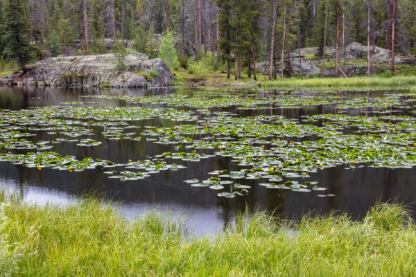
Colorado photographer and conservationist John Fielder, who says he’s been just about everywhere within the nearly 123,000-acre Holy Cross Wilderness Area, wants people to just look at his images of the fen wetlands along Homestake Creek, and then ask themselves these questions:
“Is anything more sublime and fertile and life-giving than a 10,000-or-more-year-old fen wetland? You can’t “mitigate” the loss of ancient wetlands by creating a manmade wet place somewhere else. No more water to the Front Range.”
Editor’s note: A version of this column, edited for length and clarity, was first published on Writers on the Range and subsequently in newspapers from Denver to Salt Lake City to Anchorage.


Latest posts by David O. Williams (see all)
- Democratization or ruination? A deep dive on impacts of multi-resort ski passes on ski towns - February 5, 2025
- Western Rail Coalition looks to revive passenger rail service on long-dormant line connecting Colorado mountain towns - January 22, 2025
- Colorado ski town looks to dig deep, diversify energy sources as climate change threat looms - January 10, 2025

You must be logged in to post a comment Login